Clean Water?—We’re on Top of It!
Austin Water Wildlands Conservation, Water Quality Protection Lands, Onion Creek
Christine Middleton and Mimi Cavender
Members of Hays County Chapter of Texas Master Naturalist™ enjoyed a May 20, 2023 field trip to the Water Quality Protection Lands (WQPL), Onion Creek management unit on FM967 west of Austin, Texas. WQPL is a program of Austin Water Wildlands Conservation.
Hays County Master Naturalist Vice-President Venita Fuller organized this important field trip. Christine Middleton was among the HCMN participants; her report is included here.
Two expert speakers provided insight to Austin’s Water Quality Protection Lands program, an initiative dating from 1998. Cait McCann Terán, Environmental Program Coordinator, City of Austin, Wildland Conservation Division, works to connect the public to the many corners of Austin's Wildlands, alongside volunteers, biologists, and land managers. Cait presented the History and Overview of the Water Quality Protection Lands. Devin Grobert, Senior Biologist with the City of Austin, Water Quality Protection Lands, is a specialist in plant ecology with 15 years’ experience restoring ecosystems of Central Texas. Devin presented on Savannah Management and Community-Supported Restoration.
After the lunch break, participants hiked down to Onion Creek for a field tour of landforms, vegetative cover, and surface water infiltration to the Edwards Aquifer.
WQPL’s Water Quality Preservation Lands’ Cait McCann Terán describes the City of Austin’s conservation/restoration of parts of the remaining wildlands above Central Texas’ precious groundwater. Photo: Doray Lendacky
Water? Wildlands? Conservation? Here, deep in semi-rural Hill Country, we Hays County MNs are on top of that. But densely urbanized Austin?—Why?
Because it’s all connected.
The dry section of Onion Creek that lies within the preserve’s boundaries contains fourteen small, protected water infiltration caves.
Before cities and counties and lines on a map, before housing tracts and glass towers and I-35, before human population growth and other species’ decline, rain that fell on a vast Central Texas grassland savanna filtered down through cracks and holes in limestone bedrock and into aquifers. In these underground ponds and streams, cold clear water has been protected for thousands of years; part of it seeps along underground, often springing to the surface again to continue its downhill flow through our towns and emerald swimming holes and eventually to the sea.

The hydrologic cycle. Image: Encyclopedia Britannica
With each rainfall, this hydrologic cycle that keeps everything alive continues today. But now, faster than it can recharge, our stored water is being depleted by a deadly combination of climate warming, overpopulation, overdrawn water wells, and paved-over recharge land. Texans are learning, from initiatives like Austin Water Wildlands Conservation, that if they are to save their natural heritage and protect the water that comes out of their taps, they must exercise political will. Here are two rewards:
1. Aquifer recharge—rainfall allowed to filter through natural terrain all over Central Texas, fill the aquifers, flow underground, and reemerge clean in our streams and water supply
Austin Water Wildlands Conservation reminded us that over 33% of the water that flows into Barton Springs comes from a section of Onion Creek here in Hays County. That's why protecting the recharge zone around Onion Creek is so important to the citizens of Austin. And that's why that area of eastern Hays County is among the properties purchased using bond money approved by Austin voters for the protection of the Barton Springs segment of the Edwards Aquifer.

Presentation slide: Water Quality Protection Lands, Austin Water Wildlands Conservation, 2023
2. Biodiversity—a variety of healthy, interconnected, native plants and animals
Austin, a model for us all, is being proactive in protecting land capable of sustaining richly diverse plant and animal life. Land purchased by Austin Water Wildlands Conservation, if not yet degraded, is kept natural; or it is rewilded with controlled burns and reseeded native grasses. Rainfall can then more readily sink in to recharge the clean water underground. Pollution sources---livestock, urbanization, automobiles---are absent so that a healthy biodiversity of native plants and animals can thrive.
It’s a win-win: Our tap water is clean, and some portion of the wild Texas we cherish is saved for us and our descendants.
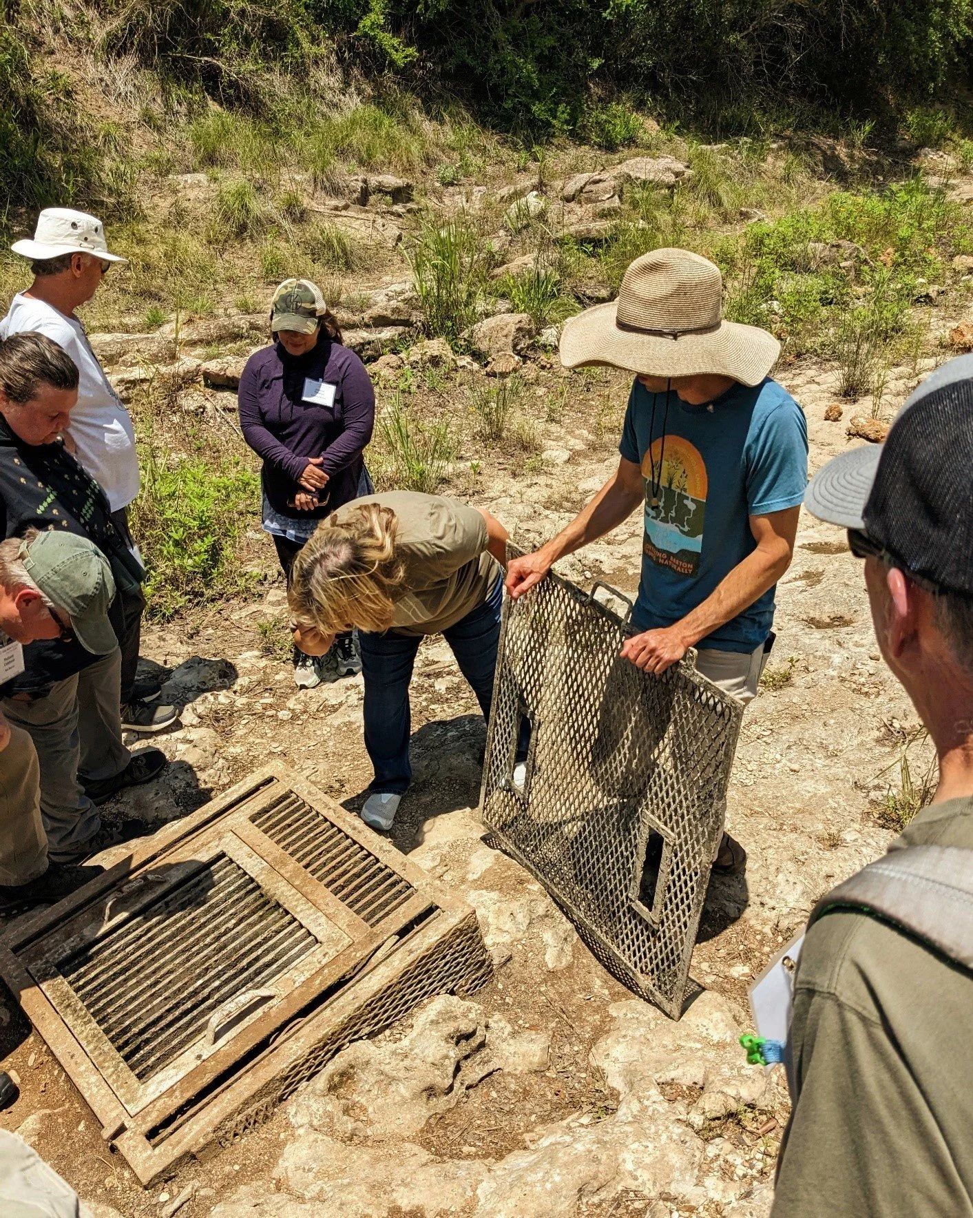
A grate protects an infiltration cave under a sometimes dry stretch of Onion Creek. Photo: Doray Lendacky
Out in the field, Hays County Master Naturalists also learned what is being done on the WQPL Onion Creek property to improve water filtration. We hiked down to Onion Creek to see how small caves in this sometimes dry section of the creek are being protected. To keep silt from accumulating in the caves and blocking the flow of water into the aquifer, grates have been placed over the openings. After a rain, volunteers and staff go out and clean off the grates. And yes, they sometimes also enter these small spaces to remove soil that made it past the barriers.

Why not a natural meadow instead of a mown lawn? Photo: Mimi Cavender
Native grasses and wildflowers, sown or allowed to naturally reseed, can transform degraded rangeland or a small acreage. A water-thirsty residential lawn can become a Hill Country meadow with all that bird and butterfly action! If we absolutely have to mow, we do it once a year—between December and February—after the warm-season grasses have dropped their seeds and before the cool-season grasses have begun to emerge.

Diverse native vegetation protects the Patsy Glenn Refuge upper meadow, running sharply downslope from a parking lot. Photo: Mimi Cavender
So improving vegetative cover across the property, especially native grasses, is another WQPL priority and a model for all of us. Research shows that grassland savanna ecosystems improve rainfall infiltration—get more water into the ground. Grasses slow runoff, hold topsoil, and allow water to move down into the aquifer.
Along a stretch of the Blanco River in central Hays County, one homeowner mows the riverbank regularly (In Texas, river frontage can be privately owned right to the middle of the stream), and in the left foreground you can see his soil thinning from erosion. Rain runoff carries pollutants from the road surface straight into the river.

To mow, or not to mow? Photo: Mimi Cavender
The homeowners downstream (top half of the photo) choose not to mow, letting natural vegetation cover the soils. Grasses slow, filter, and clean rainwater runoff, allowing purified water to move through the limestone into the aquifer below.
That means more—and cleaner—recharge of the Edwards Aquifer. To improve the ecosystem through grassland savanna recovery, volunteers for WQPL enjoy lots of activities involving gathering, cleaning, and sprouting seeds.
In upcoming issues of this magazine, we’ll be telling you more about appreciating and maintaining/enhancing our own grassland savannas.
Austin Water Wildlands Conservation maintains a beautiful website with maps and photos of the Water Quality Protection Lands and the exciting backstory of their progress. Click here!
The water that keeps living things living knows no map lines, no politics. It’s just there, precious, for our use, misuse, overuse. What I call my creek San Antonio calls the River Walk, Austin calls Barton Springs, and you call your tap water. It’s all one water. And across Central Texas we’re all on top of it.

Austin Water Wildland Conservation offers managed public access through their education programs and guided hikes. Here’s another opportunity for Texans to be outdoors in a preserved Hill Country wildland. On volunteer-led hikes, people of all ages enjoy and learn about the land, the water, and the many plants and animals for which the Water Quality Protection Lands are home. Register for upcoming WQPL guided hikes here.
Walking out across these protected lands—now forever native, natural, and pristine—we know the water runs clear and clean beneath our feet, and that our town, our parks, our land, a wider world and every living thing in it are connected by this precious water.

Blanco River, Hays County, Texas Photo: Rui Cavender